
Map #41: May 29, 2017
Difficulty Level: 4
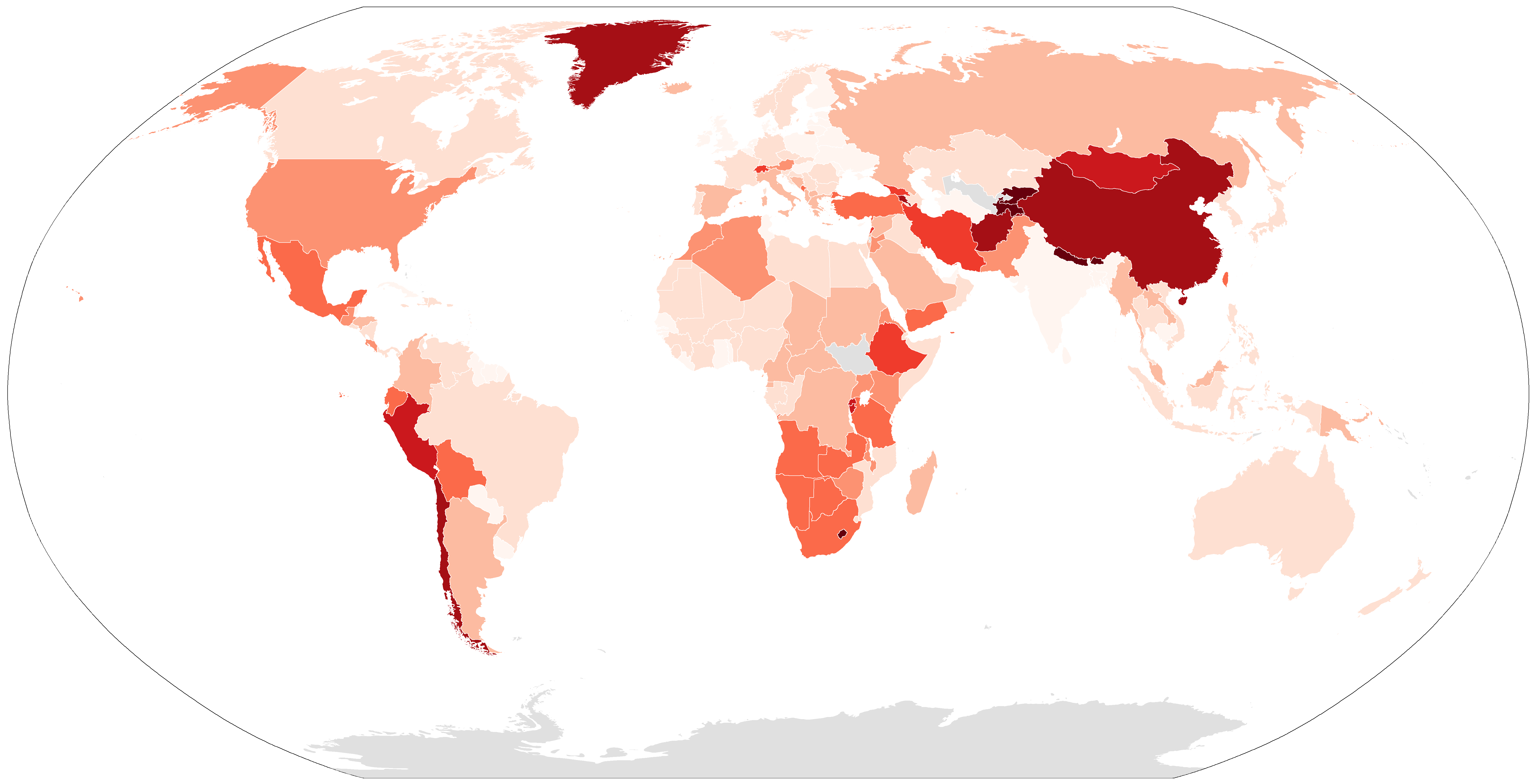
Click here for a full-size version of this week’s map.
This map is a choropleth of the countries of the world. (Do you need a refresher on what a choropleth is? Visit our “Basics” page for a quick primer.) On this map, each country (plus a few important regions like Greenland, Western Sahara, and French Guiana) is shaded in proportion to a particular statistic. Darker shades of red represent more of the statistic in question. We were not able to find accurate information for South Sudan or Uzbekistan. (Frankly, it was both surprising and frustrating that we couldn’t color in Uzbekistan, which might have been very interesting on this map!) Your job is to figure out what statistic is represented by this choropleth.
Stumped? Check back Tuesday, Wednesday, Thursday, and Friday for hints about where to focus your investigation. The answer will be posted on Monday, June 5. Good luck!
Tuesday’s hint: The first thing to notice about this map is that there are dark countries on pretty much every continent. There are also many places where there are very dark countries that border very light countries. That means that the solution is going to have to be something that can be spread around in lots of different areas, rather than something that would be clustered in particular places. One good first step for this map might be to make a list of all the countries that appear very dark so that you can try to figure out what they have in common. Did you get them all? Make sure you zoom in!
Wednesday’s hint: Most of the countries on this choropleth that are especially dark are pretty small. The smallest of all is Andorra. There’s also Lesotho. Both these countries have remained independent from their much larger neighbors because they’re fairly isolated and remote.
Thursday’s hint: One interesting feature of this map is that China is much darker than India. China and India generally have a lot in common—they’re both big countries with big populations—but there’s an important geographic difference between the two. China’s two largest subdivisions are the regions of Xinjiang and Tibet in the west. What do you know about Tibet? What might Tibet have in common with the other darkest countries on this map, such as Nepal and Bhutan?
Friday’s hint: But enough about the darkest countries—let’s talk about the lightest ones. For some of the small countries, especially island countries, we don’t have easily accessible data. Of all the countries for which we do have data, the one that would need to be colored in the lightest shade of all is the Maldives. On the day after the United States’s withdrawal from the Paris climate deal, it seems like a good time to draw your attention to the fact that the government of the Maldives held a cabinet meeting underwater in October 2009. Why did it do that? And what is so special about the Maldives that means it would be especially threatened by global warming?
Answer: Click here to see an explanation of the answer to this week’s map question.
Next map: Click here to try out our newest map question.
