
Map #42: June 5, 2017
Difficulty Level: 3
Click here for a full-size version of this week’s map.
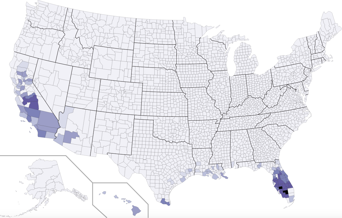
This map is a choropleth of the counties of the United States. On this map, each county is colored according to a particular statistic. We have used exaggerated scales before, but with this map, for the first time, we are using a proper base-ten logarithmic scale. That means that the darkest counties have much, much, much more of the relevant statistic than do the lighter counties. Bear in mind also that, as always, we use choropleths to map percentages, proportions, ratios, or averages, but not absolute numbers. Your job is to figure out what statistic is represented by this choropleth.
Stumped? Check back Tuesday, Wednesday, Thursday, and Friday for hints about where to focus your investigation. The answer will be posted on Monday, June 12. Good luck!
Tuesday’s note: We’re going to treat the answers this week the same way we did for Map #15, when one person earned an extra point for getting the entire answer exactly correct. In other words, you can earn full credit for getting the general idea—there’s really just one key word you need to write—but you can get a bonus point if you are completely precise.
Tuesday’s hint: All of the counties that show up on this choropleth are fairly far south, down where the weather is warm throughout the year. They are also, generally speaking, counties with fairly wet climates—or, at least, places with plentiful access to water.
Wednesday’s hint: Let’s take a look at that very light county in Florida that’s surrounded by dark counties. Its name is Sumter County, and it has the oldest median age of any county in the U.S. The largest settlement in Sumter County is an enormous retirement community called The Villages, which has a population over 150,000. This community, along with other communities that might collectively be referred to as “sprawl,” takes up much of the county. There are also a few protected wetlands in Sumter County. The question you have to answer is what you won’t find much of in Sumter County that you would find in all the neighboring counties.
Thursday’s hint: What might this same choropleth look like if we extended it to other countries? The first thing you would notice would be a lot of blue in Brazil, especially in the vicinity of São Paulo. Between them, the country of Brazil and the state of Florida are where you could find fully 85% of...what?
Friday’s hint: This choropleth is about agriculture. But what, specifically, would you find being grown in the colored areas?
Answer: Click here to see an explanation of the answer to this week’s map question.
Next map: Click here to try out our newest map question.
