
Map #33: April 3, 2017
Difficulty Level: 3
Click here for a full-size version of this week’s map.
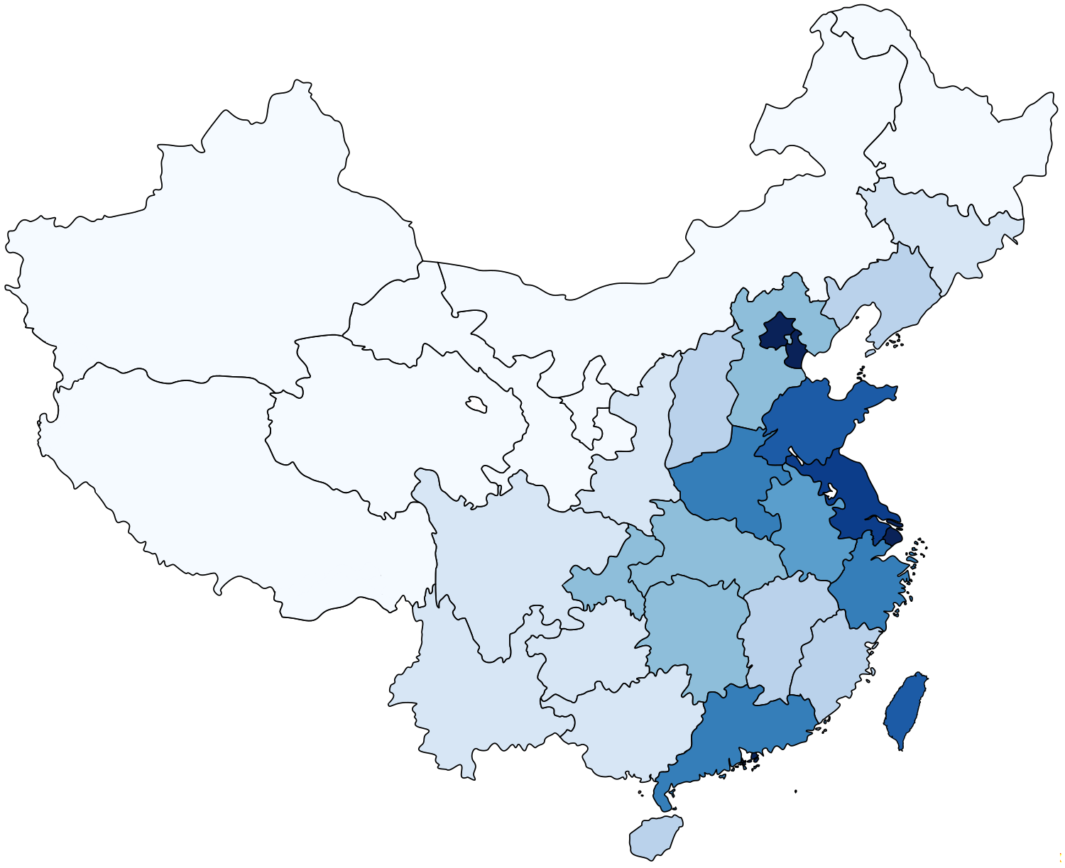
This map is a choropleth of the administrative divisions of China. (Do you need a refresher on what a choropleth is? Visit our “Basics” page for a quick primer.) On this map, each region is shaded in accordance with a particular statistic. Regions with darker shades of blue have more of the statistic in question. Your job, as always, is to figure out what this choropleth represents.
Stumped? Check back Tuesday, Wednesday, Thursday, and Friday for hints about where to focus your investigation. The answer will be posted on Monday, April 10. Good luck!
Tuesday’s hint: The scale of this map was chosen to help you differentiate among the many Chinese provinces in the middle of the range of values. That means that it isn’t as helpful at the extremes. We have seven regions with the lighest shade and five with the darkest shade. “Wait,” we hear you cry. “Five?” Yes, five. Three are fairly easy to spot, but two are very, very small. Do you see them? What’s up with those territories?
Wednesday’s hint: Some of the most lightly colored regions on this choropleth contain very inhospitable environments. For example, much of Tibet is at a very high elevation. Part of Xinjiang is covered by the Taklamakan Desert, while Inner Mongolia is partly covered by the Gobi Desert. What effects might these environments have on the demographics of these regions?
Thursday’s hint: In Tuesday’s hint, we alluded to the fact that the special administrative regions of Hong Kong and Macao are shaded in the darkest color on this choropleth. We also mentioned that this map scale isn’t intended to distinguish among regions with extreme values. If wanted to retool the scale to focus on the extremes, Hong Kong and Macao would have to be much darker than Beijing, Shanghai, and Tianjin. If only there were enough shades of blue, Hong Kong would be about fifty shades darker than Beijing—and Macao would be an astonishing one hundred and sixty-five shades darker than Beijing. Can you figure out what is so special about tiny, tiny Macao?
Friday’s hint: Setting aside the municipalities and special administrative regions, the darkest regular province on this choropleth is Jiangsu. The most populous cities in Jiangsu, such as Nanjing and Suzhou, are on the Yangtze River. The land around the Yangtze is very fertile, and this area has been home to some of China’s most important cities for many centuries. Today, Jiangsu is home to about 80 million people—about as many people as in the entire country of Turkey.
Answer: Click here to see an explanation of the answer to this week’s map question.
Next map: Click here to try out our newest map question.
