
Answer to Map #33
Click here for a full-size version of this week’s map.
Back to this week’s map and hints.
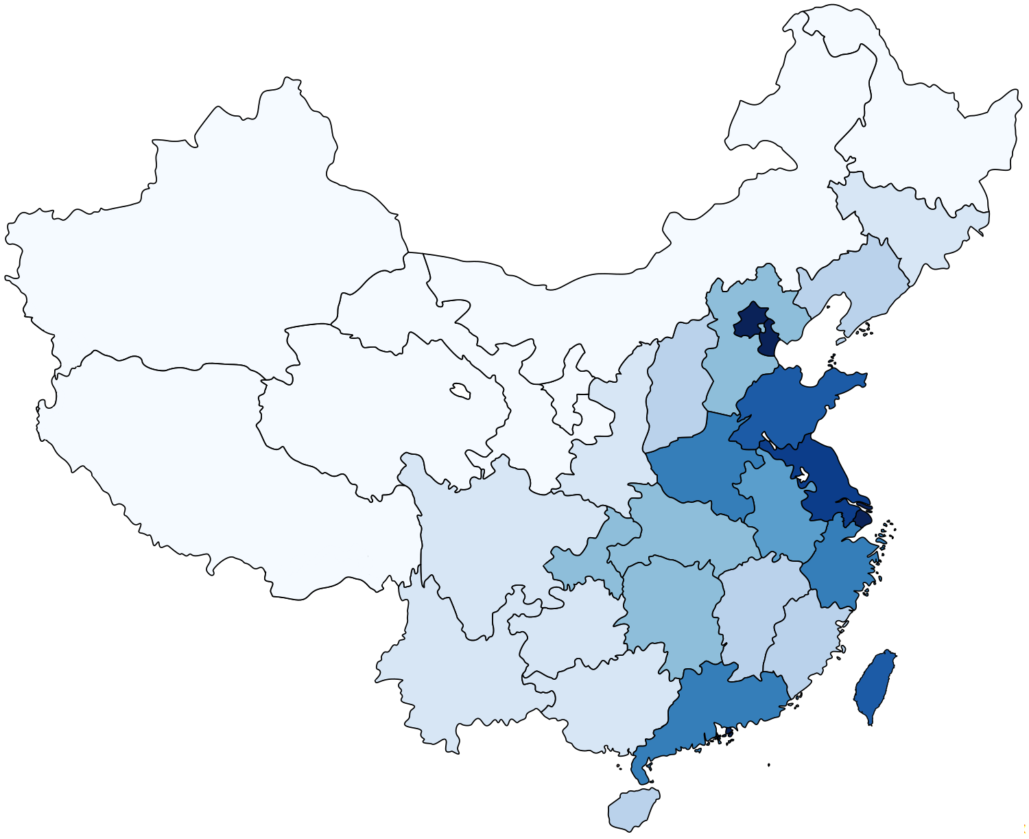
Answer: This choropleth depicts the population density of each of China’s administrative divisions.
The data used to make this map were collected by China’s National Bureau of Statistics, but you can find a handy summary of it here.
China is divided into several different kinds of regions. It contains 22 “provinces,” which you can think of as similar to American states. It also has five “autonomous regions,” which are nominally governed by members of particular ethnic minorities (Tibetan, Mongol, Uyghur, Hui, and Zhuang). Four Chinese cities (Beijing, Shanghai, Tianjin, and Chongqing) are administered independently from the provinces that surround them. Hong Kong and Macao, which reverted to Chinese rule in 1997 and 1999, respectively, are designated as “special administrative regions,” which maintain considerable autonomy (if you’ve been following the news of the past few weeks, you’ll know that this is an increasingly contentious arrangement). And, finally, we have included Taiwan on this map because it’s useful to have it here for the sake of comparison.
Inevitably, the most densely populated regions of China are the special administrative regions and the municipalities, which contain only urban areas. We designed the scale of this map to distinguish among regions in the middle range. The darkest blue on this map indicates regions with densities of more than 800 people per square kilometer. But these places actually have densities that are a lot higher than 800 people per square kilometer. Beijing, for example, has a density of 1,195 people per square kilometer. Shanghai is at 3,631 people per square kilometer. Tiny Macao, which packs 650,000 people into just 30.5 square kilometers, has a staggering population density of 17,645 people per square kilometer. It’s the most densely populated polity in the world—and it really isn’t even close. This choropleth doesn’t remotely do it justice.
But this map does help you to distinguish among China’s provinces. Jiangsu, a province in the lower reaches of the Yangtze River, is the only province colored in the second darkest shade, which indicates regions of more than 700 people per square mile. Shandong, farther up the east coast, and Taiwan are the only places shaded with the third darkest shade, which indicates regions of more than 600 people per square mile. When you look at this map, a clear trend emerges: China’s population is most densely packed into big cities and to a few core regions along the coast.
China’s westernmost regions, by contrast, are quite sparsely populated. The lightest shade on this map indicates all the divisions that have fewer than 100 people per square kilometer. Xinjiang, the largest region, has 13.1 people per square kilometer. Qinghai, right in the middle, has 7.8 people per square kilometer. And Tibet, which stretches across a barren plateau at extremely high altidue, has only 2.5 people per square kilometer.
The contrast between China’s extremely dense coastal areas and its extremely sparsely populated western regions presents both challenges and opportunities for the Chinese government. China’s leaders recognize that the country’s economic boom has disproportionately benefited people in the big cities of the east. In an effort to help the western parts of the country catch up, China has launched a series of ambitious projects in those regions. Among the most important such projects were the construction of railroads to Lhasa, Tibet, in 2006 and to Kashgar, Xinjiang, in 2011. (The railroad to Tibet in particular was a remarkable feat of engineering, since it goes over such high elevations that each train has to have a special oxygen supply.) With these sparsely populated regions now directly connected to more densely populated regions, and with more and more investment flowing into the west, it shouldn’t be surprising that lots of people are moving west. In fact, thanks to all the one-way journeys, it can be much easier to get a train ticket going east from Lhasa or Kashgar than to get one going west. The influx of Han Chinese migrants into Tibet and Xinjiang has exacerbated some of the ethnic tensions already simmering in these regions, which are home primarily to people of the Tibetan and Uyghur ethnic groups.
Next map: Click here to try out our newest map question.
