
Map #17: December 5, 2016
Difficulty Level: 5
Click here for a full-size version of this week’s map. Note that this week’s map is animated; if you cannot see the animation, please try a different browser.
This map is the first map in a five-week series. During this series, we will keep track of both the usual week-to-week scores and your cumulative score over the five-week period.
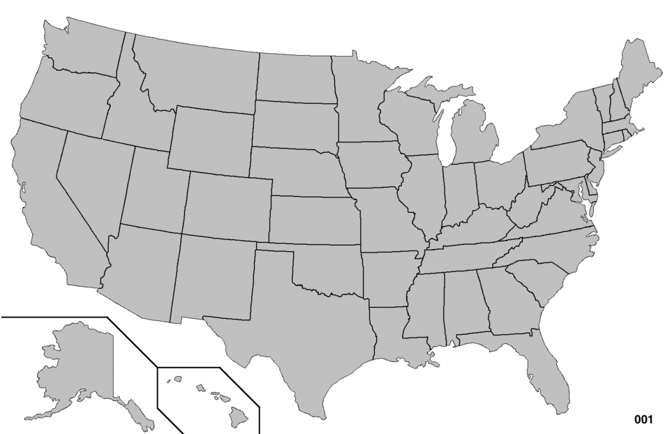
This map is an animated dot map of the United States. (Do you need a refresher on what a dot map is? Visit our “Basics” page for a quick primer.) This map is composed of 312 images that flash by in succession. We have timed each image to stay up for half a second, so it takes a total of just over two and a half minutes to watch the whole map go by (mesmerizing, isn’t it?). When it gets to the end, it waits fifteen seconds before starting over. If you want to watch a version of the map that goes more slowly, you can click here for a version in which each image lasts one second; accordingly, this version takes just over five minutes to watch from start to finish. In the bottom right of the map is a counter that increases with each image. The counter will help us draw your attention to particular sections of the map when we give this week’s hints, but the particular numbers are not themselves relevant to this week’s solution. Your job for this week: figure out what is being mapped by this dot map.
Stumped? Check back Tuesday, Wednesday, Thursday, and Friday for hints about where to focus your investigation. The answer will be posted on Monday, December 5. Good luck!
Monday’s general hint: Usually, we encourage you to solve our maps by investigating specific data points. With this week’s map, that approach probably won’t help you very much. Instead, you should be able to solve this map by looking for general trends. This is why the animation speed is fairly fast (though, as mentioned above, there is a slower version)—so that you will look for general trends rather than at specific dots.
Tuesday’s hint: One of the interesting features of this map is that dots tend to appear in particular states in sudden bursts. Consider, for example, the section from #89 through #95—there are ten dots in this section, and they are all in Wisconsin. After that, from #97 through #109, there are eleven dots, and nine of them are in New York. When you think about this map, you might want to think about why there are these bursts in which the focus seems to be on particular states.
Wednesday’s hint: It might be helpful to count out which states have the most dots over the course of this dot map. Here’s the list of the top fifteen states:
1. Florida (30)
2. Iowa (25)
3. New Hampshire (20)
3. North Carolina (20)
5. Ohio (18)
5. Pennsylvania (18)
7. Wisconsin (15)
8. South Carolina (14)
9. Colorado (10)
10. Nevada (9)
10. New York (9)
12. Indiana (8)
12. Michigan (8)
12. Virginia (8)
15. California (7)
You might want to consider what these states, especially the ones toward the top of the list, have in common.
Thursday’s first hint: Yesterday’s hint gave you the list of where the dots fell over the course of the entire 312-image run, but now let’s just look at the final ten images. There are a lot of dots clustered together at the end: Florida (6), North Carolina (4), Michigan (4), Colorado (3), Pennsylvania (3), Nevada (2), New Hampshire (2), Arizona (1), New Mexico (1), Wisconsin (1), Ohio (1), Iowa (1), Minnesota (1), and Virginia (1). These thirteen states have something in common—and they have been in the news a lot recently.
Thursday’s second hint: For those of you who have been delaying your submission because you have been trying to decide between two seemingly plausible answers, we want to point out how often Michigan appears here. Four times in the last ten images! Moreover, see that dot in Minnesota on the second-to-last image (#311)? That ought to help narrow it down for you very quickly.
Friday’s hint: Take a look at the early parts of this map. One thing you see is that there are successive periods where there are a lot of dots in particular states: first in Iowa, then in New Hampshire, then in South Carolina, then in Nevada. Can you think of any process that occurs in those four states in that order? Perhaps one that happens every four years, including this year?
Answer: Click here to see an explanation of the answer to this week’s map question.
Next map: Click here to try out our newest map question.
