
Map #107: December 3, 2018
Difficulty Level: 8
Click here for a full-size version of this week’s map.
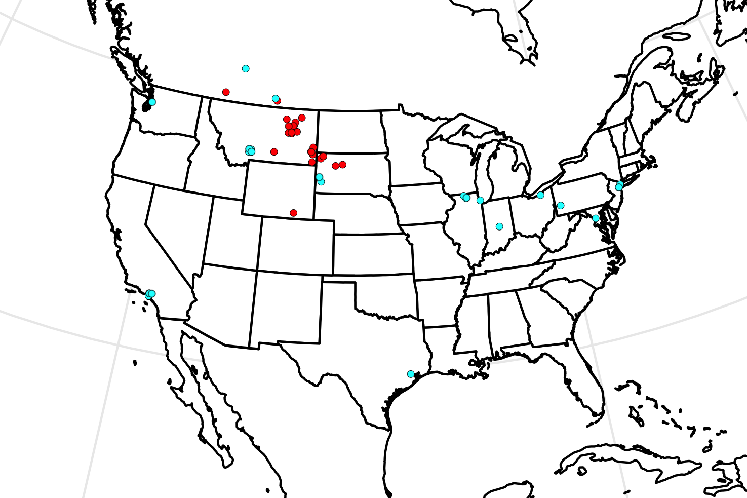
This map is a dot map of North America. (Do you need a refresher on what a dot map is? Visit our “Basics” page for a quick primer.) If this map showed more than North America, you might expect to find cyan dots in London and Berlin. We had to assemble the data necessary to make this map from some not-entirely-reliable sources, plus there was a fair amount of interpretation involved. It’s possible that some people may think there should be a few additional dots, or perhaps a few fewer dots. It’s also the case that many of the red dots had to be placed, shall we say, impressionistically. We’ll talk in the hints about why that was. Dots were staggered slightly to avoid too much overlap. As always, your job is to figure out what this dot map represents.
Stumped? Check back Tuesday, Wednesday, Thursday, and Friday for hints about where to focus your investigation. The answer will be posted on Monday, December 17, 2018. Good luck!
Tuesday’s hint: The first thing you may notice about this map is that a lot of cyan dots are in big cities (New York has two; Los Angeles has three; Chicago, Houston, Indianapolis, Cleveland, Pittsburgh, and Seattle each have one). By contrast, none of the red dots is anywhere near a big city, unless you count one that’s in the vicinity of Billings. One avenue of inquiry that may help you is to try to figure out what is going on with the cyan dots that are not in the major cities. Where are they, and why are they there?
Wednesday’s hint: The majority of the red dots are found in quite similar terrain: east of the Rocky Mountains in regions that might be classified as “badlands.” These landscapes have undergone a considerable amount of erosion. When soil and softer rocks get stripped away, the underlying bedrock is revealed. What inadvertent benefits might this process have?
Thursday’s hint: The areas in which you would find red dots not only have similar geographies today—they also share a common geological history. These regions were part of an ancient island called Laramidia, which is named after the present-day town of Laramie, Wyoming. For much of its history, Laramidia was warm and wet (in contrast to the current climate of Laramie and environs). These circumstances helped Laramidia to evolve some special characteristics.
Friday’s hint: The cyan dots on this map in New York indicate the American Museum of Natural History. Those in Southern California are for the Natural History Museum of Los Angeles. The dot in Chicago is for the Field Museum of Natural History. And the cluster of four dots in Bozeman, Montana, represents the Museum of the Rockies.
Answer: Click here to see an explanation of the answer to this week’s map question.
Next map: Click here to try out our newest map question.
