
Answer to Map #101
Click here for a full-size version of this week’s map.
Back to this week’s maps and hints.
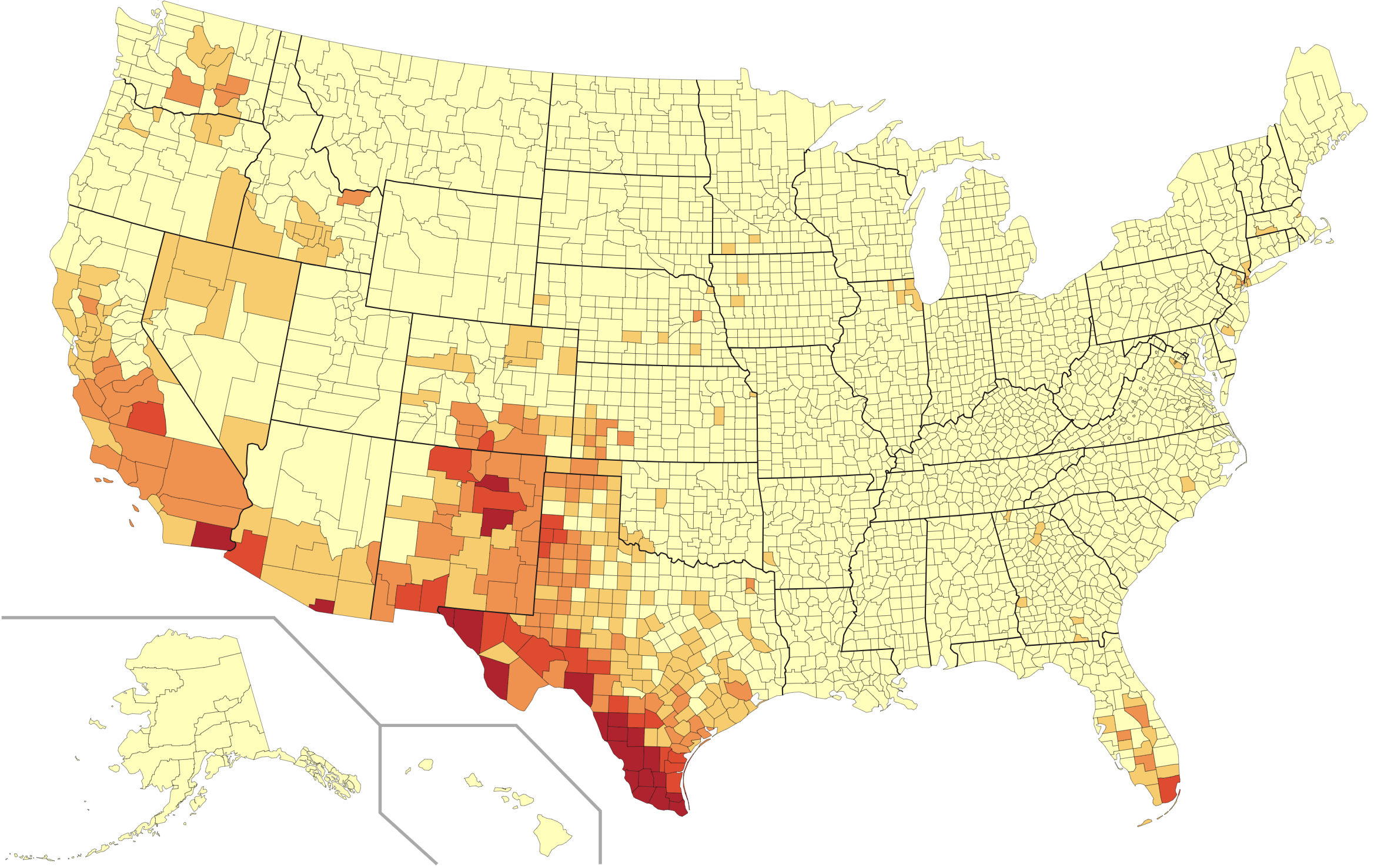
Answer: This week’s choropleth depicted the percentage of residents of each U.S. county who identified as Hispanic on the 2010 census.
What’s nice about this map is that you can see how many very different areas have significant Hispanic populations. Unsurprising, many of the most heavily Hispanic counties are along the U.S. border with Mexico. You can also see clearly that the area around Miami, which has an especially large Cuban-American population, is fairly darkly colored. So are the counties around several northern cities, including Chicago and New York. Within New York, the Bronx is the darkest borough—not surprising, since it is home to large Puerto Rican and Dominican populations. In this week’s hints, we also pointed out the fruit-growing counties of central California and central Washington, which rely on seasonal labor, much of it provided by individuals with Mexican ancestry.
Since the scale isn’t very fine here, we were pretty generous about accepting answers that were on the right track. Conceivably one could try to distinguish among the Hispanic population and the Spanish-speaking population, but we aren’t going to make you do that for a level-2 map. The basic geographic distribution is more or less the same.
The most common incorrect submission was that the map represented the percentage of people of Mexican heritage. This isn’t right! Your best hint why not is to look at southern Florida, where the majority of Hispanic people are from the Spanish-speaking Caribbean, especially Cuba, rather than Mexico.
With county-level choropleths, you’ll find that any county that stands out probably has a story behind it. For example, what’s up with the one county in North Carolina that is darker than the others? That’s Duplin County, where 15.14% of the population identifies as Hispanic—just enough to exceed 15% and get a darker color. Duplin County also has more pigs than any other county in the U.S. As a county that is so reliant on agriculture, it has attracted workers from elsewhere in the country, including many Mexican-Americans.
There’s a similar story behind Colfax County, Nebraska. Colfax County’s biggest city is Schuyler, which is not exactly surprising since both the city and the county are named for Schuyler Colfax. The economy of Schuyler is dominated by a massive beef processing plant. In recent decades, wages at the beef processing plant have gone down relative to the cost of living; as a result, many Hispanic individuals have moved to the area to take those jobs.
Counties that are totally dominated by a single industry—like Duplin County and Schuyler County—are really helpful when you’re trying to solve county-level choropleths. As you get used to this kind of map, you’ll find other counties that keep showing up with colors that clearly stand out.
Next map: Click here to try out our newest map question.
