
Answer to Map #86
Click here for a full-size version of this week’s map.
Back to this week’s maps and hints.
Dallas, who created this map, sent along the following write-up to accompany his map.
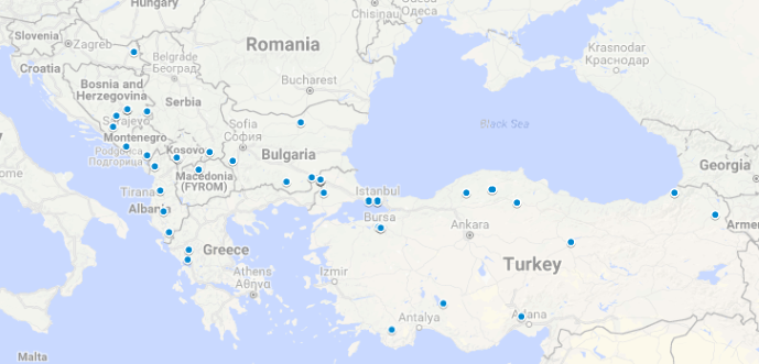
Answer: This week’s map was a dot map depicting Ottoman-era bridges in the Balkans and Turkey.
All of the dots on this map represent Ottoman bridges, but the map is not exhaustive. Part of the difficulty in creating this map was that Ottoman bridges exist in various states of completeness. Some survive today in more or less their original form, but others only survive in parts. There are some cases of Ottoman bridges that have been destroyed but renovated later. Sometimes, the Ottomans themselves simply restored a pre-existing bridge. In other cases, it’s hard to tell whether a bridge is Ottoman or from an earlier historical era! It’s also worth noting that the Ottoman Empire lasted for a very long time—from around 1300 until 1922. Architectural styles and technology changed dramatically during that time period.
That being said, it’s still possible to put together a useful map of bridges that date from the Ottoman era. And what’s especially interesting here is most of the dots on this map represent bridges from the 15th and 16th centuries—a fairly narrow time frame. Those dots are mostly located in major cities or along significant waterways.
First, a little backstory about the Ottomans. The Ottoman Empire was founded around 1300 CE in northwestern Anatolia (modern day Turkey). It quickly expanded into the rest of Anatolia and the Balkans. The Ottomans brought with them a robust architectural program. Many kinds of structures were built in Ottoman-controlled regions, including mosques, fountains, caravanseries, and bridges.
The Ottoman bridges on this map are primarily stone arch bridges. In general, Ottoman bridges combine the styles of earlier Seljuk bridges (which could be more pronounced at the top and asymmetrical) and Roman and Persian bridges (which tended to have multiple arches). The fact that many Ottoman bridges still survive today is a testament to their durability and the quality of their construction.
The golden age of Ottoman architecture occurred in the second half of the 16th century, specifically under chief architect Mimar Sinan. Sinan got his start as a military engineer and eventually turned to civil projects (including some amazing mosques, such as the Süaut;leymaniye Mosque in Istanbul). Many of the dots on the map are bridges he designed. Sinan worked under the sultan Suleiman the Magnificent, who greatly expanded the size of the empire. The range of the dots on the map illustrates pretty well the extent of Ottoman territory in Europe under Suleiman.
A few cities on the map contain multiple dots. These include Bursa, Edirne, and Istanbul, all of which served as capitals of the Ottoman Empire at some point. One of the dots in Istanbul represents the Galata Bridge (though this bridge has been built and rebuilt many times, such that it isn’t immediately clear to what extent we should classify the Galata Bridge as an “Ottoman” bridge even though the original version of the bridge dates from that era). Longtime users of site may remember the Galata Bridge from the important role it played in Map #21.
The Ottoman bridges in what is now Bosnia and Herzegovina have been the locations of especially important events in modern European history. It was in the vicinity of the Latin Bridge in Sarajevo, for example, that Archduke Franz Ferdinand was assassinated in 1914, leading to the outbreak of World War I. More recently, the Old Bridge (Stari Most) over the Neretva River in Mostar was destroyed in 1993 during the Bosnian War. Through the efforts of UNESCO, the World Bank, and other partners, the Stari Most was reconstructed using Ottoman materials and techniques and reopened in 2004. The Croatian general who ordered the bridge’s destruction, Slobodan Praljak, dramatically committed suicide by drinking poison in a courtroom in the Hague in November 2017 after he was found guilty of war crimes.
It’s worth noting the role of the Ottoman bridge in Balkan literature and folklore. The Balkans have a rich tradition of oral poetry and folk songs. One prominent folktale involves the sacrifice of a person in order to complete the building of a structure, usually by burying them alive within the walls. This motif is the subject of a folk song about the Bridge of Arta, in Northwestern Greece. It can also be found in Albanian author Ismail Kadare’s novel The Three-Arched Bridge and Yugoslavian author Ivo Andrić’s novel The Bridge on the Drina. This last novel is titled for the Mehmed Paša Sokolović Bridge in Višegrad, Bosnia and Herzegovina, which was built by Mimar Sinan. Andrić was recognized for his literary achievements with the Nobel Prize for Literature in 1961.
Finally, in this week’s hints, we alluded to one bridge that may be more familar to those of you who haven’t read much Balkan literature. Construction on the Varda Viaduct began in 1905 in what is now Turkey’s Adana Province. That viaduct was part of the Baghdad Railway, which connected Istanbul’s Asian side (this was before any bridges crossed the Bosporus) with Baghdad. The Varda Viaduct was where the pre-credit scenes of the movie Skyfall were filmed. That movie opens as James Bond falls from the viaduct and is presumed dead.
Whoever would have thought that so many Ottoman-era bridges would have so much enduring cultural significance?
Next map: Click here to try out our newest map question.
