
Map #85: April 9, 2018
Difficulty Level: 6
Click here for a full-size version of this week’s map.
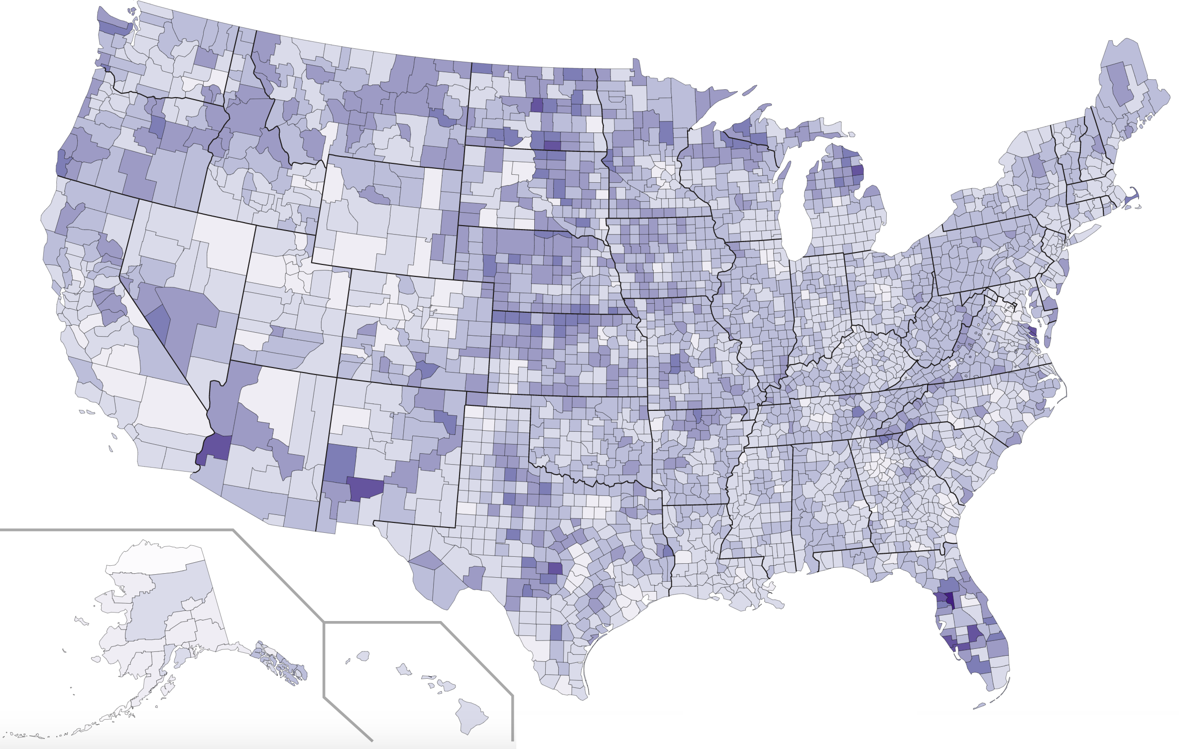
This map is a choropleth of the counties of the United States. (Do you need a refresher on what a choropleth is? Visit our “Basics” page for a quick primer.) On this map, each county is shaded in accordance with a particular statistic. Darker shades of purple indicate counties with more of the statistic in question. As always, your job is to figure out what this choropleth represents.
Stumped? Check back Tuesday, Wednesday, Thursday, and Friday for hints about where to focus your investigation. The answer will be posted on Monday, April 16, 2018. Good luck!
Tuesday’s hint: One good place to start is to try to identify what’s unique about some of the counties that are much lighter than their neighbors. For example, many counties with large cities appear quite light. So do some counties that contain Native American reservations. So do some counties with large military bases. What other types of counties are quite light? What might all these counties have in common?
Wednesday’s hint: Yesterday’s hint mentioned that most heavily populated areas were fairly light, but there is an exception to that trend: the state of Florida. Some of Florida’s biggest cities aren’t that dark, but the areas surrounding them mostly are. What is special about those central counties of Florida?
Thursday’s hint: The darkest county on this map—by some margin!—is Sumter County, Florida, which is home to a place called The Villages. What kind of a person might live there?
Friday’s hint: If you look at enough county-level choropleths, you’ll start to feel familiar with certain counties that are frequently outliers. Sumter County, Florida, is one such county; you may well remember it from the hints to Map #42, our map of citrus cultivation. Another frequent outlier (though it’s so small you may have missed it) is Kalawao County, Hawaii. Kalawao is the smallest county in the U.S. It occupies just a tiny, isolated peninsula on the island of Molokai. Its population is so tiny that it doesn’t even function like a normal county; instead, it is administered directly by Hawaii’s state health department. That’s because this part of Molokai was once used to isolate patients who suffered from leprosy. Thanks to modern medicine, leprosy is no longer such a daunting problem, but it was once so contagious that people who were afflicted with it were shunned from mainstream society and dispatched to isolated locations. Though leprosy patients have long been free to leave Kalawao County and reintigrate into society, many have chosen to remain on that part of Molokai. As of 2015, there were 16 former patients remaining in Kalawao County. That may not sound like a lot, but remember that we’re talking about one of the least populated counties in all of the U.S. Sixteen people is actually a huge percentage of the county’s population. Now, bearing in mind that these people were all treated for leprosy in this area prior to 1969, when the quarantine policy was lifted, what might be true about the demographics of these particular people (and, consequently, this particular county)?
Answer: Click here to see an explanation of the answer to this week’s map question.
Next map: Click here to try out our newest map question.
