
Map #72: January 8, 2018
Difficulty Level: 7
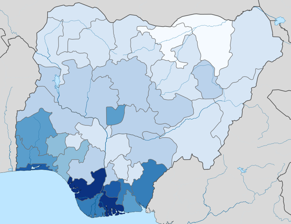
Click here for a full-size version of this week’s map.
This map is a choropleth of the states of Nigeria. (Do you need a refresher on what a choropleth is? Visit our “Basics” page for a quick primer.) On this map, each state is shaded in accordance with a particular statistic. Darker colors represent more of the statistic in question. This map uses a linear scale. As always, your job is to figure out what statistic is represented by this choropleth.
Stumped? Check back Tuesday, Wednesday, Thursday, and Friday for hints about where to focus your investigation. The answer will be posted on Monday, January 15, 2018. Good luck!
Tuesday’s hint: Many people have been guessing that this map depicts the percentage of Christians in each state. This is an intriguing guess, but it is not correct. The religious divide in Nigeria between north and south is much starker, and on a map of Christians you would see darker shades in many of the inland provinces of the southern part of the country. Instead, the correct solution to this map is not related to religion.
Wednesday’s hint: One interesting feature of this map is that several of Nigeria’s most populous cities are in provinces that are very dark. Lagos, the country’s largest port and financial center, is especially dark. So is the federal district that surrounds Abuja, the country’s inland capital. Both of these cities are rapidly increasing in population as people move there from the countryside. Why might you prefer to live in Lagos rather than a more rural area?
Thursday’s hint: The darkest states on this map are located in the area of the Niger River delta, which is the center of Nigeria’s oil industry. Obviously, the presence of many oil derricks in these states has something to do with the color. But as you ponder submitting a solution, be careful: every state in Nigeria has some shading on this choropleth, but not every state is the site of oil production.
Friday’s hint: The two lightest states on this map are Yobe and Jigawa, both of which are in the northern part of the country. Both of these states are primarily agricultural; most of the people who live there are engaged in subsistence farming. These states are covered by fairly dry grasslands, and they are being deforested at an alarming rate. They are not, in other words, easy places to be a subsistence farmer!
Answer: Click here to see an explanation of the answer to this week’s map question.
Next map: Click here to try out our newest map question.
