
Map #64: November 6, 2017
Difficulty Level: 4
Click here for a full-size version of this week’s map.
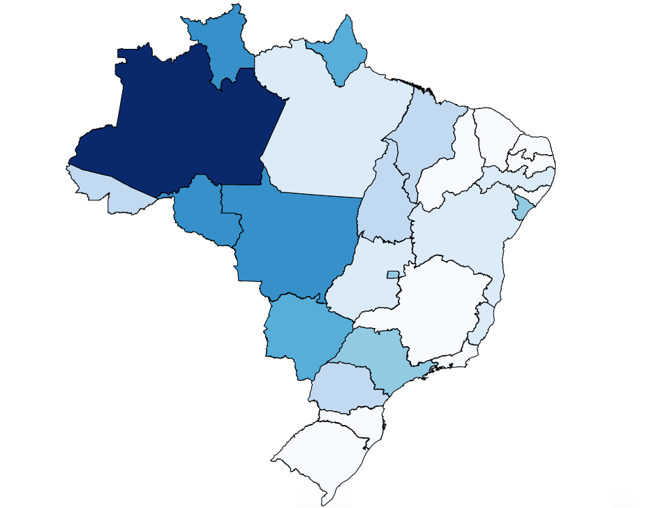
This map is a choropleth of the states of Brazil. (Do you need a refresher on what a choropleth is? Visit our “Basics” page for a quick primer.) On this map, each state is shaded in proportion to a particular statistic. Darker colors indicate that a state has more of the statistic in question. As always, your job is to figure out what this choropleth represents.
Stumped? Check back Tuesday, Wednesday, Thursday, and Friday for hints about where to focus your investigation. The answer will be posted on Monday, November 13. Good luck!
Tuesday’s hint: One interesting feature of this map is that a few states that are home to big cities stand out from their neighbors. One is the Federal District, home to the capital of Brasília. The other is São Paulo, Brazil’s most populous state (and namesake of Brazil’s most populous city). The fact that some cities stand out—however faintly—are an indication that the solution has to do with political geography rather than physical geography.
Wednesday’s hint: The darkest state on this map, by a considerable margin, is Amazonas. Amazonas, Brazil’s largest state by area, covers an enormous swath of tropical rainforest surrounding the Amazon River and its tributaries. The population of Amazonas has been growing for a long time as people move there to take advantage of economic opportunities (most of which involve, in one way or another, chopping down the rainforest and polluting the waterways). In 1972, Brazil inaugurated the Trans-Amazon Highway, a road that runs from the Atlantic Ocean all the way into the heart of Amazonas. Not only has the highway brought economic investment into the state, but it has also brought many migrants from more populated parts of Brazil. As a result of this influx, the shade of blue in Amazonas is getting lighter and lighter. Prior to 1972, it would have been considerably darker. Prior to the big rubber boom in Manaus in the 1890s, it would have been extremely dark.
Thursday’s hint: Another very dark state on this map is Amapá, which borders Suriname and French Guiana. Amapá is not very developed. In fact, about 70% of the state is made up of dense, unexplored forests. Whereas most states in Brazil have experienced extensive deforestation, Amapá has lost only about 2% of its forest. The state is also home to one of the world’s largest national parks. All this means that Amapá hasn’t had the same influx of migrants that has come to many other Brazilian states. What do you think the demographics would be like under such circumstances?
Friday’s hint: Finally, one more state that appears fairly dark on this map is Roraima. Roraima is an interesting state because nearly half of the entire land area of the state—about 46%, to be precise—has been legally set aside to be inhabited by a certain group of people. Which group?
Answer: Click here to see an explanation of the answer to this week’s map question.
Next map: Click here to try out our newest map question.
