
Answer to Map #36
This week’s map is split into two pieces, each of which depicts a major world city. Here are links to larger versions of the first map and the second map.
Back to this week’s map and hints.
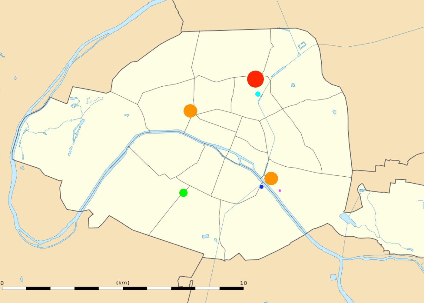
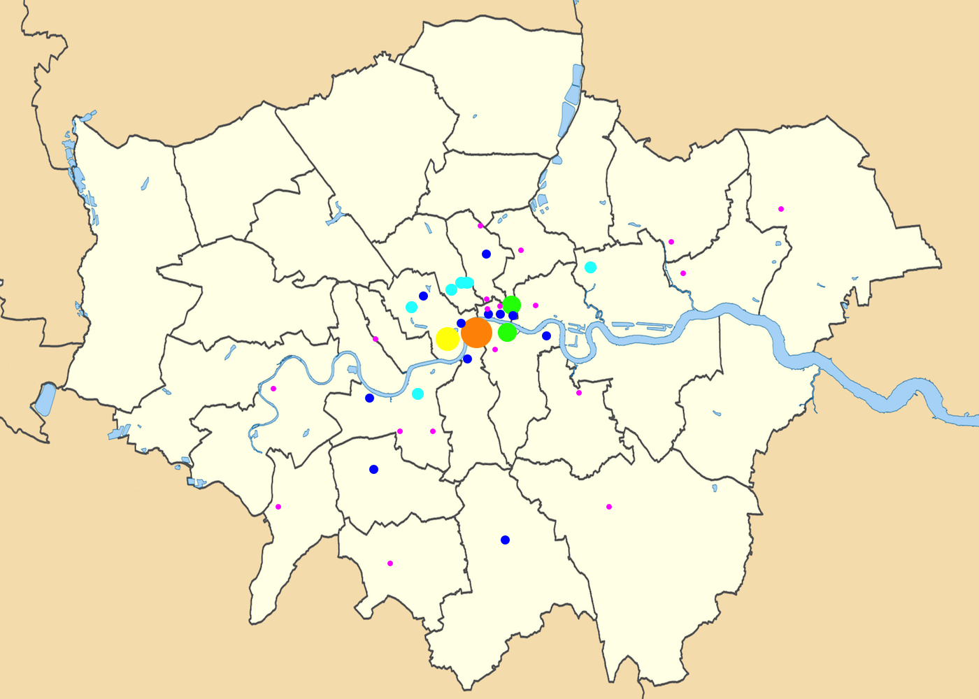
Answer: These proportional symbol maps depict the train stations of London and Paris, with the size of each symbol proportional to the number of passengers who pass through each station.
The lone red circle on this map corresponds to the Gare du Nord, the busiest station in Europe, which served 214,220,327 passengers in 2014. The orange circles indicate stations that serve more than 90 million passengers per year: Gare Saint-Lazare and Gare de Lyon in Paris and Waterloo Station in London. Waterloo, which is the busiest station in the United Kingdom, serves only about 99,148,000 passengers in a year according to the latest estimates—a number that would make it only the fourth busiest station in Paris.
Wednesday’s hint drew your attention to the dots for London’s St Pancras International and Paris’s Gare du Nord. These stations are linked by the Eurostar train, which passes through the Channel Tunnel between Great Britain and the European mainland. In addition to Paris, trains from St Pancras also go directly to Brussels.
While these maps help to highlight how much busier the busiest stations in Paris are than the busiest stations in London, we don’t want you to get the wrong idea about the number of passengers in these cities. The statistics for both London and Paris are absolutely dwarfed by those of Tokyo. According to one estimate, Tokyo’s Shinjuku Station serves approximately 1.26 billion passengers per year—more than five times as many as Gare du Nord. One list asserts that, of the world’s 51 busiest train stations, all but six are in Japan.
In both London and Paris, this week’s maps show only the stations that serve the main intercity lines, omitting the commuter stations on the London Overground and Paris’s RER. This stylistic choice is perhaps unfair to Paris, since some of the RER stations serve very large numbers of passengers, but it does serve to highlight some of the main differences between the British and French rail systems, starting with the fact that the United Kingdom’s passengers are spread around to more stations, while French passengers are more concentrated.
In order to understand why each city’s stations are arranged as they are, we have to look back to the early history of the railroad in the mid-nineteenth century. In the United Kingdom, the first railroads were constructed by private companies, which built their own stations and competed against one another. Since they weren’t allowed to build lines all the way into central London, a ring of competing stations sprung up around the city. In 1863, the first line of the London Underground opened to connect many of these stations to one another.
In France, by contrast, the building of railroads was encouraged and overseen by the central government. The entire country’s rail system was centered on Paris, with the result that it was often difficult to go between any two French cities without going through Paris to get there, even if it was far out of the way. The various stations of Paris were carefully assigned to serve trains going to particular parts of France. Gare du Nord, for example, was the terminus for trains that traveled north from Paris. To a great extent, these original divisions are still in place today.
Next map: Click here to try out our newest map question.
